

Provision of hazard maps
ENTRY DATE: 10.04.2012 | LAST UPDATE: 10.04.2012
CATEGORIES:
- Coastal Regions
- Observation systems, information dissemination
TECHNOLOGIES MATURITY:
Applicable immediately
Technology Owners:
Local governments; consulting firms
Needs Address
The need to reduce damage in regions that may be affected by more intense storm surges from climate change and damage from inundation due to tropical cyclones, etc.
Adaptation effects
・ In particular, negative human impacts will be reduced (resident capacity for self-preservation will increase, vulnerability to climate change will decrease, and proper actions during disasters will be promoted) through the provision to residents and others even in times of no emergency, of information such as evacuation methods, and information about water depth and starting time of inundation events caused by storm surges, flooding, and so on.
・ Increases in vulnerability to climate change will be suppressed by the use of basic information when preparing land use plans.
Overview and Features
・ Hazard maps indicate on maps the potential water depths and inundation areas that could be damaged by inundation due to storm surges, tsunamis, and flooding, etc., and provide additional information about disaster prevention (evacuation areas and routes, etc.).
・ The inundation zone, depth, and starting time is calculated by computer simulation, based on external factors such as typhoon storm surge level, tsunami height, rainfall, as well as land elevation, infrastructure such as protective structures (shore embankments, river embankments, etc.), and factors such as the disaster management features of facilities.
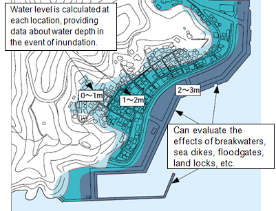
Water depth projections (inundation zone, depth)
Source: http://www.mlit.go.jp/kowan/hazardmap/hazardmap_3.pdf
It is important that local residents become familiar with the hazard maps, and methods to do this include distribution of printed materials, the installation of disaster information boards, and so on. When preparing hazard maps, to promote residents' disaster awareness and to clarify the hazards (probability of occurrence of tsunami height, typhoon, flooding, etc.), it is useful to hold workshops and use other methods involving local resident participation.
Cost
Five to 10 million yen per town or city, excluding costs for analysis of tsunamis, storm surges, and flooding, etc. (costs of analysis can vary with the scope and subject, ranging from 10 to 50 million yen)
Considerations
・ The collection and organization of basic information is required to prepare hazard maps (analytical software, plus information about typhoons, tsunamis, flooding, and topographical maps (50 meter contours), hydrographic maps (50-meter depth contours), and information about coastal protection structures, etc.)
・ Personnel capacity is needed in order to prepare hazard maps.
・ In order for local residents and others to know where to obtain information and conduct themselves appropriately in a disaster, it is important to promote awareness, and conduct trainings and education on an ongoing basis during non-emergency times.
Co-benefit, suitability for developing countries
・ Even in areas where major infrastructure/physical measures cannot be immediately implemented due to cost or time constraints, etc., it may be possible to reduce damage by raising awareness about disasters and evacuation.
・ Public awareness is enhanced by having residents participate in the preparation of hazard maps.
Information Resources
・ Cabinet Office (Disaster Management), Rural Development Bureau of the Ministry of Agriculture, Forestry and Fisheries, Fisheries Agency of the Ministry of Agriculture, Forestry and Fisheries, River Bureau of the Ministry of Land, Infrastructure and Transport, and Ports and Harbours Bureau of the Ministry of Land, Infrastructure and Transport (2004): “Tsunami and Storm Surge Hazard Map Manual”
http://www.icharm.pwri.go.jp/publication/pdf/2004/tsunami_and_storm_surge_hazard_map_manual.pdf
・ Flood Control Division, River Bureau, Ministry of Land, Infrastructure and Transport (MLIT) (2005): “Flood Hazard Mapping Manual in Japan”
http://www.icharm.pwri.go.jp/publication/pdf/2005/flood_hazard_mapping_manual.pdf
・ Ministry of Land, Infrastructure and Transport and Tourism; Infrastructure Development Institute – Japan (2003): "Summary of Flood Hazard Map Manual"
http://www.mlit.go.jp/sogoseisaku/inter/keizai/gijyutu/pdf/flood_manual_j.pdf (in Japanese)
・ River Bureau Ministry of Land, Infrastructure, Transport and Tourism, Japan (2010): "Practical Guidelines on Strategic Climate Change Adaptation Planning – Flood Disasters – "
http://www.mlit.go.jp/river/basic_info/english/pdf/guigelines_eng.pdf
・ International Centre for Water Hazard and Risk Management (ICHARM), Public Works Research Institute (PWRI) (2010): “Progress Report on Flood Hazard Mapping in Asian Countries”
http://www.icharm.pwri.go.jp/publication/pdf/2010/4164_progress_report_on_fhm.pdf