

Long term monitoring (observation of waves, tide levels, shore lines, etc.)
ENTRY DATE: 10.04.2012 | LAST UPDATE: 10.04.2012
CATEGORIES:
- Coastal Regions
- Observation systems, information dissemination
TECHNOLOGIES MATURITY:
Applicable immediately
Technology Owners:
Port and Airport Research Institute; Japan Meteorological Agency; equipment manufacturers, etc.
Needs Address
Collection, accumulation, analysis, and evaluation of long-term data relating to climate change, which provides content for consideration of climate change impacts and countermeasures
Adaptation effects
・ Long-term and continuous data collection and accumulation relating to climate change will result in valuable information for consideration of countermeasures.
・ An R&D framework will be created to analyze and assess long-term monitoring results.
Overview and Features
Wave observation involves installation of wave meters (submerged, floating, or near shore, etc.), and using ultrasound, water pressure, GPS, and so on, to observe such parameters as wave height, period, and direction. Various types of observation equipment exist, but some are indicated here.
– Ultrasound wave gauges: Observation devices for sea surface behavior that work by emitting ultrasound waves from submerged transducers (on the sea floor, etc.) and by measuring the time to return after being reflected from the surface. In the case of placement on the sea floor, typically a few km from shore, and at a depth of 30 to 50 m.
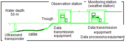
Japan Meteorological Agency's ultrasound coastal wave observation system
Source: http://www.data.kishou.go.jp/kaiyou/db/wave/obsdata/uswsys.html
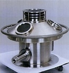
Part of Doppler-type direction water meter sensor for installation on sea floor
– Doppler-type direction wave meter: Wave meter that uses the Doppler effect of ultrasound waves transmitted through water. Releases omnidirectional ultrasonic waves from the sea floor, measures/analyzes the behavior of water particles, thereby analyzing wave characteristics (height, period, direction) as well as frequency, directional spectrum, and simultaneously, tide levels.
Source: http://www.pari.go.jp/unit/kaisy/theme/1.html
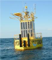
GPS wave meter
– Buoy-type wave meter: Observes waves by measuring behavior of waves using either moored or drifting buoy. Various models use GPS, accelerometers, etc. Can take observations at points offshore.
Source: http://www.mlit.go.jp/report/press/port05_hh_000009.html
・ For tide level observation, the rise and fall of sea water flowing in and out of a tide well via an inlet pipe is measured from a fixed point in a tide station. Most commonly used are the float type, which measures the position of a float in the tide well, and the ultrasound type, which measures the time required for a reflection from the water surface to return to a transponder placed at the top of the well.
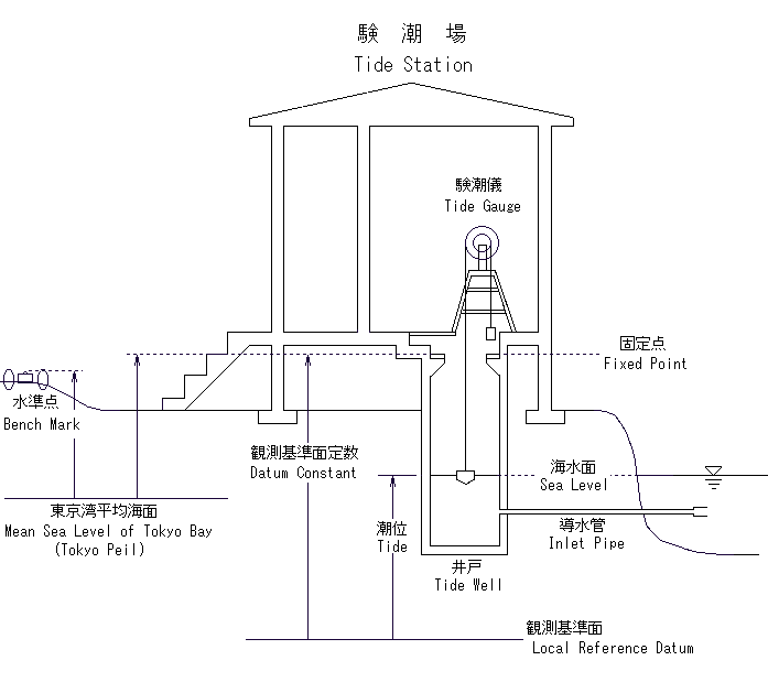
Source: http://tide.gsi.go.jp/comment.html
Cost
・ Costs vary considerably depending on design of system (number of monitored sites and control stations, transmission network, etc.)
・ The per-unit cost of buoy-type GPS wave meters, with real-time data transmission function, etc., is in the hundreds of million yen.
・ The per-unit cost of tide gauges, with real-time data transmission function, is about 10 million yen.
Energy source
Electricity
Ease of maintenance
It is necessary to improve institutional arrangements for operation/maintenance/upkeep, and to have adequate training of personnel.
Considerations
・ If observation equipment and information transmission infrastructure is not in place, costs will be incurred for installation of observation equipment, transmission lines, data collection systems, etc.
・ With the installation of observation equipment, it is also necessary to improve institutional arrangements for operation/maintenance/upkeep, and to have adequate training of personnel.
・ To use this system for disaster prevention, besides observation and data collection it is also important to improve warning/notification equipment and to discuss/notify the relevant personnel about its operation.
Co-benefit, suitability for developing countries
・ Depending on the information being collected, it may be possible to select the design with consideration of costs.
・ Data obtained can also be useful as basic information for other purposes, such as construction of port facilities; planning/design/construction of port and shore projects; and for development/use of coastal zones.
・ Can also be utilized for monitoring storm surges and tsunamis.
Information Resources
・ Nationwide Ocean Wave information network for Ports and HArbourS (NOWPHAS) (Ports and Harbours Bureau, Ministry of Land, Infrastructure, Transport and Tourism) (wave height/period, wave direction)
http://www.pari.go.jp/unit/kaisy/nowphas (in Japanese)
・Tide level observation (Japan Meteorological Agency, Japan Coast Guard, Geospatial Information Authority of Japan, local governments, etc.)
http://www.jma.go.jp/jp/choi (in Japanese)
・Japan International Cooperation Agency (Global Environment Department) 2011: "Handbook on Climate Change Adaptation in the Water Sector: A Resilient Approach that Integrates Water Management and Community Development"
http://gwweb.jica.go.jp/km/FSubject0301.nsf/3b8a2d403517ae4549256f2d002e1dcc/45c3d4e20234bf0849257735000e0592/$FILE/Handbook%20on%20Climate%20Change%20Adaptation%20in%20the%20Water%20Sector%20Ver.1%202011.pdf